

RAP, residents express concern about plans to narrow Willow Branch Creek

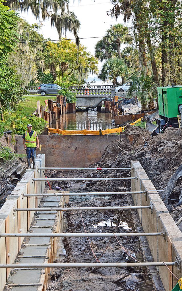
Construction of a bulkhead along the banks of Willow Branch Creek between St. John’s Avenue and Riverside Avenue is underway and neighborhood observers and members of Riverside Avondale Preservation have been startled to see the creek was to be made narrower than they envisioned.
As it is currently being installed, the city’s project to restore Willow Branch Creek will actually decrease the width of the creek from 17 feet to 12 feet near its mouth, though the city says that will not reduce its capacity.
That came as a surprise to Riverside Avondale Preservation.
“This creek has to be able to handle more water, not less, and flow freely into the St. Johns. The city engineer says it won’t affect the creek’s ability to handle water but that doesn’t make sense,” said Brooks Andrews, president of the RAP board.
“This is a historic park and with all the flooding issues, it feels like this project has been rammed through. It’s a disgrace,” Andrews continued. “Maybe what they are doing is environmentally and scientifically based, but we can’t defend it to the neighborhood. We don’t know what’s happening, but it looks like an absolute disaster.”
RAP had requested the plans for the project this summer and were sent the original plans drawn up in 2013. But the project was revised in April and those revisions were communicated to RAP, said Warren Jones, RAP executive director.
The contractor is installing precast concrete walls along the east side of the creek between Riverside Avenue and the St. Johns River.
“We were under the impression that the walls were going to be stair-stepped like the old walls. They say they can’t do it with the new walls,” Jones said. “According to the plan the walls are supposed to be four feet high. But the water is already over the walls, so we’re not sure if they’re going to be higher.”
Public Works Director John Pappas said the current plan is to narrow the channel to ensure the project does not adversely impact the existing residential buildings along the east side. The buildings are very close to the creek and there are concerns about getting close to their foundations.
The project has been designed to control the capacity of the water through this area of the creek, Pappas said.
The current plan is for the creek to be 12 feet wide but the project engineer is evaluating the possibility of moving the west wall farther out to allow for a wider channel, Pappas said.
Neighbors report that already during heavy rains and high tide, water comes over the concrete bulkheads.
In June, two residences near the creek were flooded by a storm during a king tide.
Chuck and Shawn Jensen said their house was flooded and the air conditioner, washer, dryer and freezer had to be replaced.
“We’ve lived here 19 years,” Chuck Jensen said. “I’ve seen high water but I never knew it could be that bad. The owner of the company apologized and gave me his insurance information. They Fed-Exed the check to the house practically the next day. They took care of me. But if this happens again there’s going to be an issue.
Jensen said he doesn’t fault the construction company, which he said is just following orders from the city.
“But it’s too narrow,” he said. “What they’re putting in has already been underwater.”
Pappas said the impact from king tides will not change. “Keep in mind that this project is to replace the existing creek bulkheads,” he said.
RAP has had several meetings with Pappas and City Council Member Randy DeFoor about the issue.
“They said they are going to try to broaden it on the other side so that it is 17 feet,” DeFoor said. “They’re listening. They’re going to get back to us in a couple of weeks.”
Erosion is another issue. Dirt and debris from the project is washing into the creek, which flows into the yacht basin, which has silted in and is no longer navigable.
The silting began several years ago after the bridge at Riverside and Willow Branch was replaced, but it’s gotten worse since the creek project began. RAP has video of dirt sliding into the creek and there are areas of obvious erosion.
“At low tide you can walk across the yacht basin,” said Cathleen Murphy, a RAP member who lives nearby. “They were supposed to make improvements, but instead they made it worse. The yacht basin has been ignored. It used to be navigable. Now it’s unusable.”
Jones complained about the erosion to DeFoor who called the state Department of Environmental Protection, which is testing the water for suspended solids.
She also has called the Army Corps of Engineers about the silting. If a project is going to have a silting issue, she said, the Army Corps needs to issue a permit. She’s not sure if one was issued for this project.
Pappas said the contractor has installed two floating turbidity curtains on the downstream, the south side of St. Johns Avenue, and a third floating turbidity curtain on the upstream, the north side of St. Johns Avenue. The contractor is also placing filter fabric over exposed material to reduce erosion.
The infrastructure in the canal dates to the platting of the neighborhood in the 1920s. Its function is to drain several miles of the neighborhood.
The $831,115 restoration project was planned in 2013 as part of Mayor John Peyton’s Better Jacksonville Plan but didn’t begin construction until this year at Olga Street with the undergrounding of the canal.
“The scope hasn’t been revisited since then to include public input or to take into consideration resiliency,” Jones said.
Resiliency wasn’t an issue until Hurricane Irma in 2017 when the whole area was flooded, most memorably Memorial Park, where the iconic statue was almost under water and the balustrades were ripped out.
RAP has always been very protective of its trees, many of which are more than 100 years old. But the canopy has taken on new meaning in the era of resiliency, and the restoration plan would remove about 75 trees from the park, mostly along the creek.
RAP protested the removal of so many trees and the city said it would look at how to reduce the number that will need to be removed.
“They’re talking about replacing them with things like palms and crepe myrtles. Those are the wrong trees for storm water management,” Brooks said.
Jimmy Orth, executive director of the St. Johns Riverkeeper, said the city needs to think of trees as part of the city’s public works infrastructure.
“The canopy of a tree holds an amazing amount of water that doesn’t hit the ground and the roots absorb a tremendous amount of stormwater. They purify the air,” Orth said.
“You just can’t take out a mature tree and pay into a mitigation fund or plant a sapling. It will take decades for that sapling to be big enough to do the same stormwater management,” Orth said, adding that the existing trees around the project are probably already damaged by the heavy equipment sitting on their root systems.
Both RAP and the Riverkeeper would like to see the concrete bulkheads abandoned in favor of a living shoreline with a gradual slope that is lined with plants that are resilient to rising water and provide habitat.
The concrete bulkheads degrade over time and aren’t absorbent, Brooks said.
Though it may be too late to change the project between Riverside Avenue and the river, other sections of the canal in the park might be able to be revised, DeFoor said, noting she is asking the Federal Emergency Management Agency about using Willow Branch Creek as a pilot project for a living shoreline.
“It’s about changing mindsets,” she said. “Irma changed priorities. People look at resilience. Engineers think in terms of hardening, which is not necessarily the best response. Hardening is expensive and short-term.”
Orth said turning Willow Branch Creek into a living shoreline “is an opportunity to show the city what a creek restoration should look like. That would make it much more natural and attract people. And create a more resilient area.”
By Lilla Ross
Resident community News
 (No Ratings Yet)

