

City launches interactive bikeway and shared-use paths online tool
Last month, the City of Jacksonville’s Transportation Planning Division of the Planning and Development Department (PDD) launched its “Off-Street Bikeways and Shared-Use Paths (Trails) Network Tool.”
This interactive web map allows users to identify and select the quickest and easiest path to travel by to reach their destination, be it by bicycle or on foot (where shared-use trails are available).
“The City prioritizes transportation system safety, in an effort to eliminate fatalities throughout the operation of a complete multimodal transportation network, which this new public resource will help to achieve,” stated a city press release about the tool’s launch.
In 2017, the City compiled a “Pedestrian and Bicycle Master Plan” with a mission to “develop a prioritized network of recommended bicycle facilities for City and State roads located within the I-295 Beltway.” In its overview, the plan identified Jacksonville as a city with “many of the necessary characteristics of walkable and bicycle-friendly communities” but also, at the time, other characteristics “that contribute to a less than safe, comfortable and convenient walking and bicycling experience.”
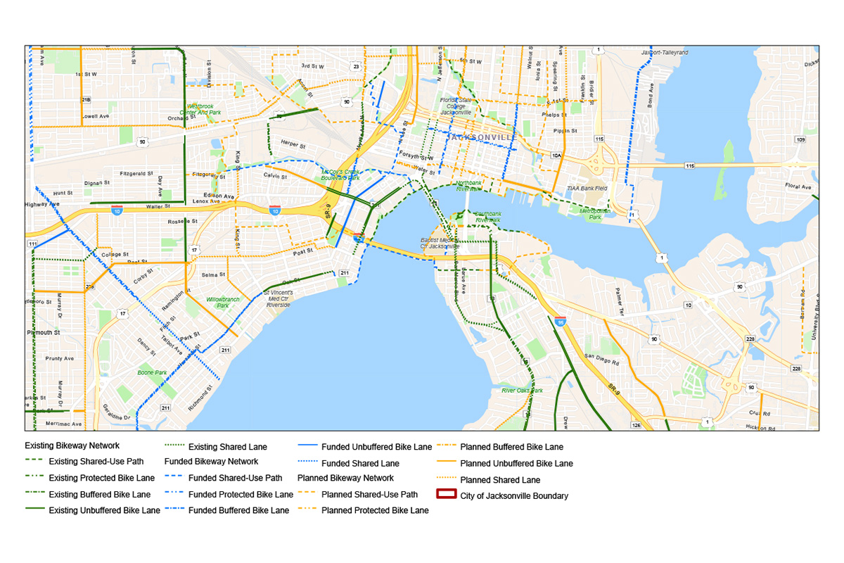
According to the City of Jacksonville’s website, the network of “on-street bicycle trails and pathways” today covers 887 miles with 55 miles consisting of shared-use paths for bicycles and pedestrians. Another 90 miles of trails are either funded and “planned trails in the works.”
This interactive and informative tool adds a new layer of safety and convenience, allowing users to map out and print their ideal route from point A to point B before they even hit the pavement.
In a statement regarding the network tool, the PDD said, “Viewers of the tool can also click on specific facilities to determine the length, facility type, location, ownership, of the routes.”
Facilities — pathways, trails or lanes — are color-coded on the map for convenience: Existing facilities are featured in green; planned facilities are yellow; and funded facilities are blue. Facilities are also identified and broken down by type: buffered/unbuffered bike lanes, shared lanes, shared-use paths or protected bike lanes. Users are also able to view and download available data on these facilities.
“Using this large dataset to extrapolate information regarding existing, planned, and funded facilities, we can begin to upgrade facilities with a low BLOS [“Bicycle Level of Service] and ensure that planned and funded projects are designed to accommodate users of all ages and abilities.”
By Michele Leivas
Resident Community News

 (2 votes, average: 4.50 out of 5)

