Riverplace ‘road diet’ gains final approval
Posted on July 3, 2017 By Editor Articles, Neighborhood News, Top Stories

As you travel north on Hendricks Avenue and reach the intersection of Prudential Drive, you will soon be greeted by what appears to be a new neighborhood. A large new sign will proclaim “Southbank.”
From your vantage point at the stop light it will look like nothing you’ve ever seen in Jacksonville’s urban core, or perhaps anywhere in the city. It will, of course, be the same Southbank neighborhood it’s always been, but it will have a new level of neighborhood aesthetic and opportunity.
Since the idea was presented to the public in September 2015, the project has been called the Riverplace Road Diet plan. After much discussion, design work and consultation with City of Jacksonville and infrastructure officials, the Downtown Development Review Board (DDRB) unanimously voted June 15 to approve the design, right down to the color of the concrete pavers used in the sidewalks.
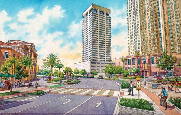
The new project will transform the 2000-foot Riverplace Boulevard, between Main Street on the west and Prudential Drive on the east, from a wide and unwieldy expanse of well-worn pavement, into a 21st-century neighborhood corridor (albeit a short one) that will efficiently and effectively accommodate motor vehicles, bicycles and pedestrians.
- The goal of the “road diet” is to better serve diverse groups of people with different needs. To that end the plan includes the following:
- reduce the travel lanes to initiate “traffic calming”
- landscape the corridor for a more attractive streetscape
- create protected bicycle lanes
- large delineated crosswalks and lighting for pedestrian safety
- street furniture for relaxing and socializing
- create better access to the Southbank Riverwalk
- improve accommodations for public transit
- 36 on-street parking spaces
- improved wayfinding signage
The Southbank has a long history as a vibrant waterfront. In the 1920s, it was comprised of a working-class neighborhood, with grocery stores, parks, churches, pubs and industry. Residents lived close to their work. In the 1960s the area transitioned into single-use office buildings, and workers drove in from the suburbs, which necessitated more of a highway system to get people in and out of the city. In the ‘90s the Southbank changed again with expanding medical facilities and fewer residents. At the time the city consciously dismantled the waterfront with its “close-in” residential neighborhoods, and effectively turned the Southbank into a land of parking lots. Even today you can still see remnants of the evolution of the Southbank over the past 90 years.
The Riverplace Road Diet will provide welcome relief from the Southbank’s busy and diverse past. It’s a change in purpose. A change from moving cars and trucks, rapidly and in bulk, to providing safe efficient mobility for pedestrians, bicycles, and to a lesser degree motor vehicles. The redesign of Riverplace Boulevard will make it easier and safer for residents of The Strand and The Peninsula high-rises to cross the road. The growing interest in bicycling will be served by having a dedicated bike lane that is removed from the street and protected from parked cars.
This people-friendly design is expected to bring in more retail and restaurants along the street, said Lori Boyer, City Council immediate past president, who also represents District 5 in which the Southbank is located.
“One aspect is the public safety aspect,” Boyer said. “The other aspect is the economic vitality of the whole area. If you go down there at night right now, it is dead on Riverplace Boulevard. That’s what we want to change.”
Nick Mousa of GAI Consultants, the company that designed the project, noted several features of the new construction that will offer significant neighborhood improvements, including installation of new signage directing people to a public access point for reaching the Riverwalk, which Mousa said ties in with getting more active use of the river; new bike lanes (which don’t currently exist) that will tie-in with the bike lanes coming off of Hendricks Boulevard, and tighter driveways from the existing establishments with clear demarcations.
This new design is a real-world application intended to safely accommodate the needs of people today, said Mousa.
The changes to the road reflect the wide variety of development that is emerging on the Southbank. It offers the waterfront, a renowned medical district, proximity to the historic neighborhood of San Marco, the advent of The District and other planned residential developments close to Riverplace. The area will soon have all the elements to attract residents looking for restaurants, biking and walking, in a people-friendly neighborhood with a modern, welcoming look and feel. It is hoped that Riverplace Boulevard will lead the way to pedestrian and bicycle safety in other areas of Jacksonville, and be the first step in the process of how the entire area will evolve.
It should be a restorative time for the Southbank. It will provide residents with a sense of order, and visitors a sense of arrival. It’s the beginning of an infrastructure overhaul, a sustainable model where residents will be drawn to amenities and activities of the day. It is hoped to lead down a road toward long-term success on the Southbank Riverfront. Where once was a dated Southbank thoroughfare where cars, people and bicycles seemed to meander about without much concern for lanes or boundaries or rules, there will soon be a clean, modern, 21st-century urban transportation corridor that works efficiently for motorists, and safely and comfortably for pedestrians and bicyclists.
The Riverplace Road Diet plan now goes out to bidding, contracts and finally construction.
By Lloyd Lemons
Resident Community News


 (2 votes, average: 4.00 out of 5)


