

St. Nicholas resident wants city to move historic marker

More than 200 years ago, when the Spanish occupied what is now known as Jacksonville, a small Spanish garrison once stood just west of the athletic fields of present-day Bishop Kenny High School in St. Nicholas. In the median of Atlantic Boulevard between Assumption School’s soccer field on the north and 50 feet north of the White Avenue-Atlantic Boulevard intersection on the south, lies a historic marker indicating the exact location of Fort San Nicholas. Erected by the Jacksonville Chapter of the Daughters of the American Revolution on May 17, 1930, the marker indicates that the fort, which was first built sometime around 1740, existed 1,530 feet north of the marker.
E.J. Helow, a St. Nicholas resident, wants to have the marker moved. In early July, Helow wrote a letter to the St. Nicholas Area Preservation (SNAP) Board requesting that it discuss the possibility of moving the marker to St. Nicholas Train Station Park, so that residents and visitors might be able to enjoy it.
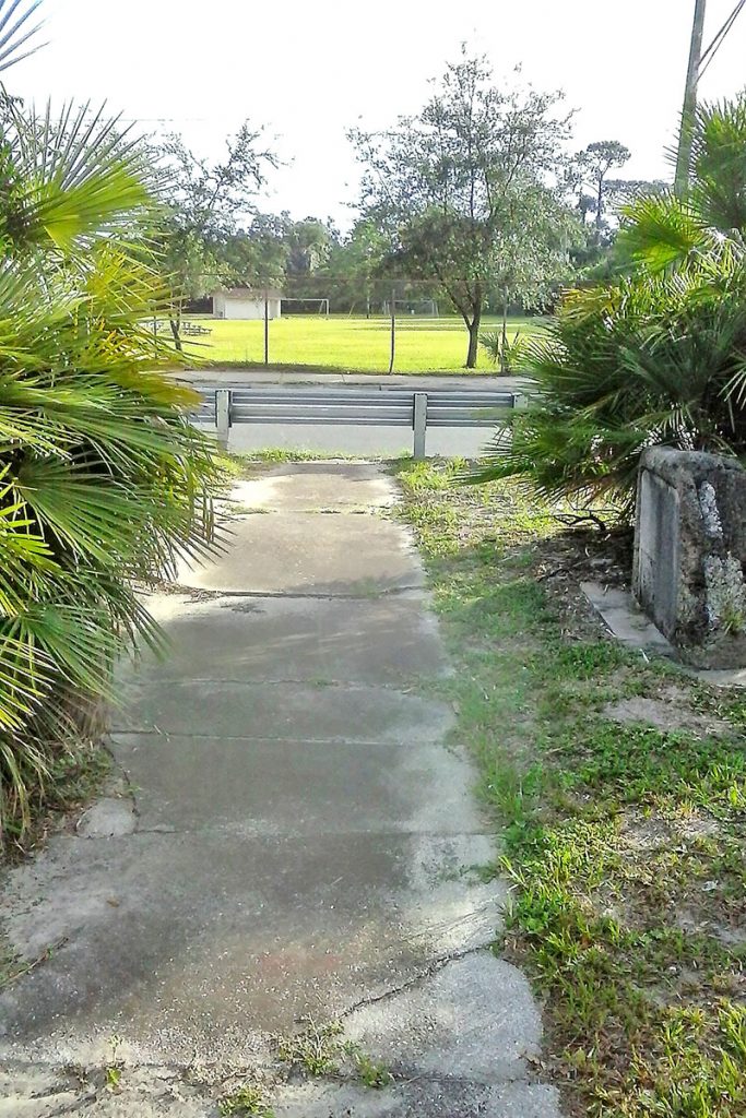
“Several months back FDOT (Florida Department of Transportation) installed a barricade/guardrail on the north side of the Atlantic Boulevard median. It appears the reason for that was to protect the digital signs and periodic visits by technical personnel from the voluminous amount of traffic westbound on Atlantic Boulevard,” Helow said, noting that the marker, which has a small paved footpath leading up to it, is now hidden and partially inaccessible. “The current location is not convenient to get to and potentially dangerous with all the traffic east and westbound,” he said.
The colonial fort served as a Spanish stronghold to defend Cowford Crossing across the St. Johns River; to protect settlers and missionaries from Indians; to help preserve Spanish interests in Florida against the British and the Americans; and to prevent smugglers from using the St. Johns River, according to an article written by Glenn Emery on jaxhistory.org.
Built in 1740 by Governor Manuel de Montiano in anticipation of an English attack by General James Oglethorpe, the fort was located at a strategic crossing of the St. Johns River and remained in use until the British occupied Florida in 1763. It is unclear whether the British used the fort during their 20-year occupation, but when the Spanish returned, they refurbished the blockhouse and added a 100-foot square moat around it. In 1796, John H. McIntosh captured and destroyed the fort as revenge for the Spanish having appropriated some of his property. The Spanish again rebuilt the fort only to see it destroyed again during the Patriots War. It was rebuilt again. After the Spanish ceded Florida to the United States in 1821, the fort was used by the Americans as a customs house and to prevent smuggling, according to fortwiki.com.
The fort was abandoned on July 4, 1817, according to the marker.
SNAP President Jay Harrington and Vice President Bubba Miller said Helow’s suggestion will be discussed at the board’s August meeting, Monday, Aug. 5. Miller expressed some concern about moving the marker due to the fact it was specifically placed to indicate the exact location of the fort.
“I see that FDOT created a barrier that blocks the sidewalk made to get to the marker,” said Miller. “But you can’t really move the marker because it tells exactly where the fort was located from that particular place. It’s cool, and it’s overgrown with palmettos, but the problem in my mind is moving it when it says the fort was located 1,530 feet north of this spot. However, I can see that it is frightening to cross three lanes of Atlantic Boulevard to go see it.”
In a discussion about the marker during SNAP’s recent happy hour event at Mudville Grille, one suggestion was to place the historic marker in St. Nicholas Train Station Park and have the city embed a plaque in the ground at the present location so that information would not be lost.
Helow, who has lived in the San Marco area since he attended Assumption School in first grade more than 60 years ago, said he feels something should be done about the marker because it is a visible reminder of St. Nicholas’s rich history. He first went to SNAP hoping they would be able to better appeal to the city to have the marker moved. “When the barricade was put up by FDOT, I said, ‘this isn’t right. Why don’t I bring it up to SNAP.’ It was the perfect opportunity to get the wheels rolling,” said Helow.
“I don’t see how anybody could object to this,” he continued. “I feel certain those of us residing in the St. Nicholas neighborhood and the businesses within could encourage the Jacksonville Historical Society and others to make this existing monument area something more than it is now,” he said.
By Marcia Hodgson
Resident Community News
 (1 votes, average: 5.00 out of 5)

